5 best marine navigation apps in 2023
Marine navigation apps are incredibly helpful for sailors and fishermen who need to plot a course and stay on course at sea. They provide real–time navigation and tracking information, weather forecasts, and a variety of other features. With the right app, you can easily plot a course, track your progress, and stay safe while out on the water. Here are some of the best marine navigation apps to help you find your way. 1. Navionics: This is one of the most popular marine navigation apps.
It provides detailed maps and charts, live weather conditions, and even satellite imagery. It also offers advanced features like route planning and route optimization. Plus, it’s compatible with a range of popular devices, including Apple and Android phones and tablets. 2. iNavX: This app offers detailed satellite charts, weather forecasts, and real–time navigation information. It also provides course–plotting features and tide and current tables. Plus, it’s compatible with a range of devices, including tablets and phones.
Contents
Navionics Boating is an app that provides an extensive library of navigational features, including up–to–date nautical charts, satellite imagery, tides and currents, and more. The app is available for both iOS and Android devices.
Navionics Boating is a comprehensive marine navigation app providing features such as:
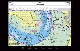
- High-definition nautical charts: Detailed coverage from around the world and exclusive 1-foot HD bathymetry charts for the US and Canada.
- Plotting and route planning: Create, customize, save and share routes and waypoints for planning and navigating.
- Advanced features: Sync with leading chartplotters, view tides and currents, search with SonarChart™ Live and more.
- Satellite imagery: View aerial photos of coastal and inland areas for an up-close view of the environment.
- SonarChart™: View real-time bottom contours overlaid on the chart to reveal depths and seabed structure.
- Dynamic tides and currents: Monitor tidal heights and currents in real-time to maximize safety and efficiency.
- Social sharing: Connect with a community of boaters to share and view each other’s routes and waypoints.
- Weather forecast: View up-to-date weather information and forecasts for a safe and enjoyable boating experience.
iNavX is a powerful marine navigation app that provides you with detailed vector and raster charts, tides and currents, and AIS data. It’s available for both iOS and Android devices.
Features
- Built-in 6-axis MEMS gyroscope and accelerometer for precise motion sensing
- On-board magnetic sensors for compass heading and declination
- High-speed, low-latency data connection via Bluetooth or USB
- On-board calibration and alignment algorithms for maximum accuracy
- Configurable data rate, orientation and output rate
- Fully integrated with popular software platforms and autopilot systems
- Industrial grade design and construction for the most demanding applications
- Built-in vibration isolation for maximum stability and accuracy

SeaNav US is an app that provides detailed marine charts and navigational data for the United States. It’s available for both iOS and Android devices.
Features
SeaNav US is a mobile navigation and charting app for recreational and commercial boaters. It includes a range of features, including:
- Integrated charts: View detailed nautical charts for the US and Canada, with support for vector, raster, and NOAA RNC charts.
- Tides and currents: Get accurate tide and current times for over 6,000 locations in the US and Canada.
- Marine weather: View real-time weather information, including wind and wave forecasts, radar, and satellite imagery.
Routing: Plan a route and follow it on the app’s chart using advanced navigational features. - GPS tracking: Track your current location and view your speed, course, and distance traveled.
- AIS tracking: View the location of nearby vessels broadcasting AIS signals.
- MOB tracking: Automatically save the position of a person in the water and track it on the chart.
- Anchor alarm: Get an alarm when your boat moves out of a designated location.
- Navigation library: Access reference material, including rules of the road, navigation lights, and international buoys.
4. MarineTraffic:
MarineTraffic is an app that allows you to track the movements of vessels around the world. It’s available for both iOS and Android devices.
Features
- Vessel Tracking: Track vessels in real-time, including their location, speed, heading, and more.
- AIS Data: Access Automatic Identification System (AIS) data collected from thousands of vessels worldwide.
- Historical AIS Data: Access historical AIS data to trace vessels back in time and analyze their movements.
- Ship Photos: View photos of thousands of vessels to get an understanding of their size and condition.
- Marine Weather: Monitor weather conditions at sea, including wind, wave height, and temperature.
- Maritime News: Keep up to date with the latest maritime news and developments.
- Port and Terminal Data: Access information about ports and terminals around the world.
- Vessel Management: Monitor vessels, fleets, and crew performance with a range of vessel management tools.
- API: Access MarineTraffic data through an easy-to-use API.
- Notifications: Receive notifications when vessels approach, enter, or leave ports, or when key events occur.
5. Ship Finder:
Ship Finder is an app that allows you to track vessels in real time. It’s available for both iOS and Android devices.
Features
- Real-time ship tracking
- Ship search by name, type, call sign and more
- Dynamic map with port and harbor info
- Vessel information including AIS data, speed, and course
- Marine traffic density and congestion
- Smart alerts and notifications
- Historical tracking and playback
- Ship photo library
- Weather data including wind speed, wave height, and sea state